The world of men (Manusya-loka)
The middle world (Madhya-loka) is the only one of the three worlds where it is possible for men to be born. Even there, rebirth and death are restricted to a relatively small area. It comprises: Jambū-dvīpa and Lavana-samudra, the continent (Dvipa) of Dhātakīkhanda surrounded by the 'Black-water ocean' (Kālodadhi), and the inner half of the third continent, called 'Lotus-island' (Puskara-dvīpa), which lies on the inner side of the circular mountain barrier called 'Beyond humankind' (Mānusottara) to signify that it serves as a limit to the normal human domain.
The artists' fantasy is revealed in those spaces where they respect the essential points of reference and most of the distinctive characteristics, while at the same time treating rather freely proportions and various details (see Fig. 1). One can see, for example, how they reduce the distance which separates the two shores of the oceans, which are theoretically twice as large as the continents which they surround.
Jambūdvīpa, especially, is painted in great detail: long chains of mountains running from east to west divide it into seven countries; great rivers flow from the peaks to the oceans; and the division of the provinces can be seen in the large middle zone of Videha, to the east and west of Mt. Meru, whose peak dominates Uttarakuru in the north, and Devakuru in the south, with their respective trees, Jambūvrksa and Śālmall.
The Himavat mountains in the south, and usually their northern counterparts also, extend into the Lavana ocean where there are always at least two of the vast receptacles (Pātālas) which cause the tides. The islands attributed to the moons and the suns are usually depicted.
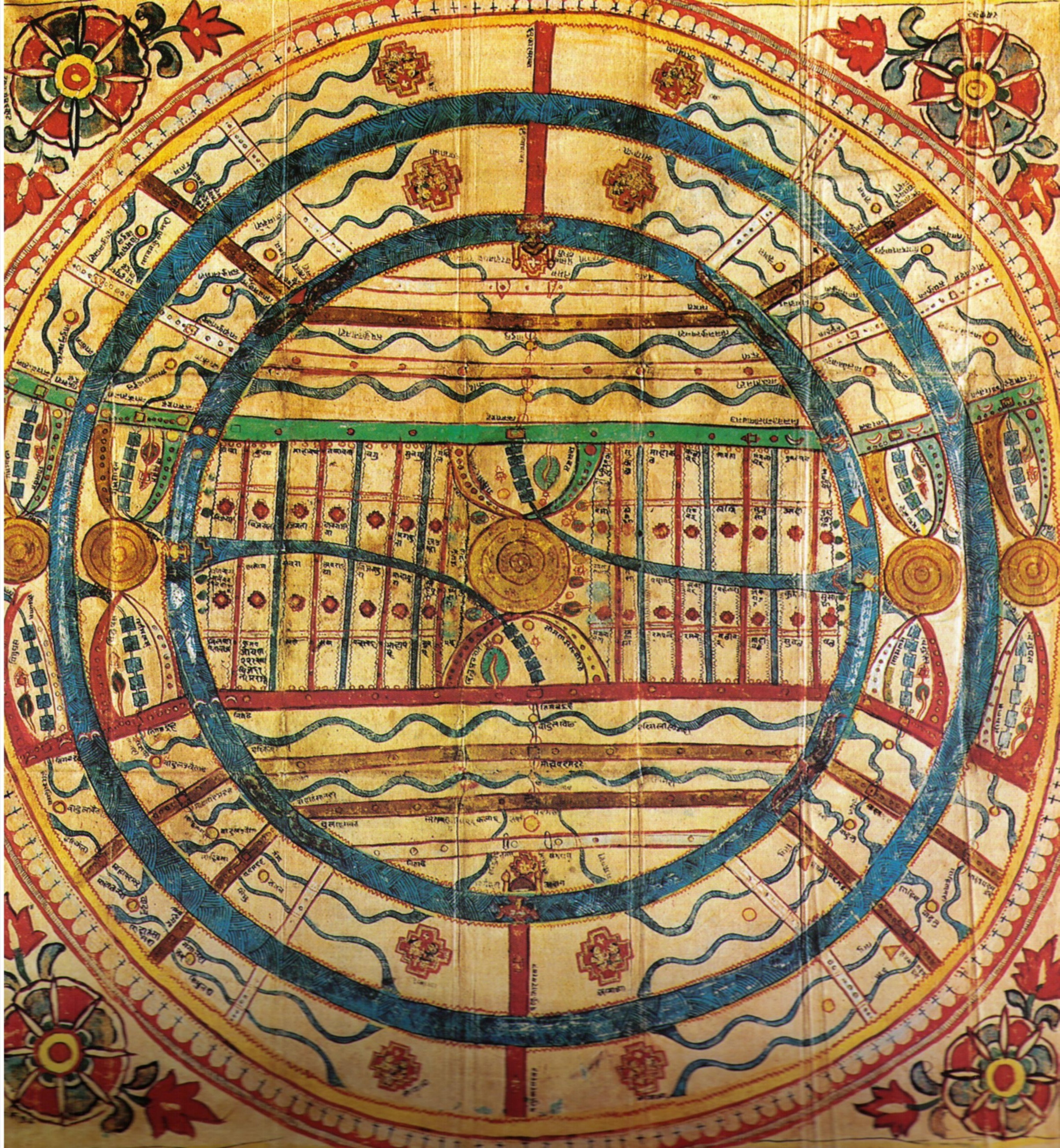
Fig. 1. Map of the 'two and a half continents' (Adhāī-dvīpa) which it occupies (Gouache on cloth, 16th century, Gujarat)
The disk of Jambū-dvipa (see Fig. 2) is set within its rampart of diamonds, which is surrounded by a fence of jewels crowned by a high garland of lotuses made from gems. It is washed by the Lavana-samudra where the tides which regulate its months rise, where the islands of its moons and suns are situated, and into which some of its mountains project.
At the four cardinal points four 'triumphal' gates open on to the ocean. Through the east and west of these, named Vijaya and Vijayanta, project the mouths of the two principal rivers of the middle land.
Six main mountain ranges cross the continent from east to west, and thus divide it, from north to south, into seven lands. The three to the north of the central area occupied by Mahāvideha correspond symmetrically with the three to the south.
At the very south is the land of Bharata (in which will be recognised the name of India); Airāvata is an exact replica of this at the north. From Bharata to Mahāvideha, and similarly on to Airāvata, the size of the countries and of the mountain chains between them increase by geometrical progression, by a factor of two. So Videha is 64 times larger than the land of Bharata.
The map (Fig. 2) shows especially the long mountain ranges by which the intermediate countries are bounded. Their peaks are crowned with sanctuaries. Rising from huge lakes in the mountain heights, long rivers flow down to where a peak impedes their course and turns them towards the east and the west, until they finally flow into the Lavanasamudra.
The geography of Bharata (and Airāvata) follows the same pattern, but with more details. Bounded at the north by the Himavat mountains, which project into the sea the double promontories of the Damstrās, each carrying seven red spots which represent the Antaradvīpas, Bharata is cut again from east to west by the range of the Vaitādhya mountains, bristling with nine peaks. From the central lake of the Himavat mountains the River Sindhu flows towards the south-west, and the River Gangā towards the sourth-east. Their streams flow on either side of Mt. Rsabhagiri - the dwelling place of the first prophet - and then penetrate the Vaitādhya mountains. Re-emerging, they spread out in the plains where there are capital cities like Ayodhyā, before emptying themselves, by means of vast mouths, into the Salt Sea.
Mahāvideha is even more complex. In the centre is Mt. Meru, to which are joined, to the north and south, the two pairs of ranges of the 'Elephant-tusk' (Vaksārd) mountains, whose arcs enclose the two Kurus, Devakuru (where the Śālmalī tree is found) to the south, and Uttarakuru (where the Jambū tree grows) to the north. The map shows the open spaces at the foot of Mt. Meru, towards the east and west, where the forests grow, to which correspond the woods (unusually visible here) which lie on the shores of the ocean.
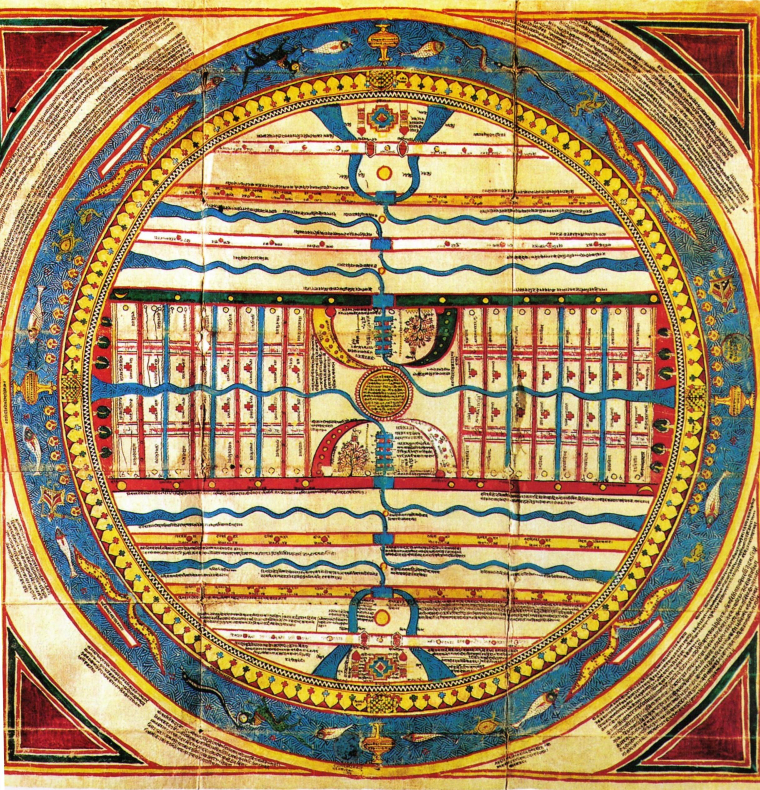
Fig. 2. The Island of the Rose-apple tree (Gouache on cloth, 16th century, Gujarat)
Text and Photos from: C. Caillat / R. Kumar, Jain Cosmology, Hongkong/New Delhi 2004, pp. 118, 142; Pls. 54, 74.